Key message: In the period from 1953-2018 the area under forest has doubled
Assessment: The indicator shows trend of changes of forested area in the territory of the Republic of Serbia. It is used by forest authorities, but also by biologists and ecologists in order to assess percentage of forested area compared to the total area of the Republic of Serbia. Changes in forest area due to forestation, renewal or deforestation, represent an indicator for sustainable forest management and to monitor the role of forest ecosystems in the global carbon cycle.
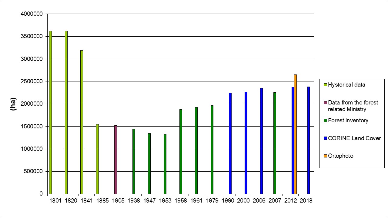
According to CORINE Land Cover for 2018, the area under forest in the Republic of Serbia (excluding the territory of the Autonomous Province of Kosovo and Metohija) was 2,380,917 ha, or 30% of the territory, while according to SPOT5 satellite images, the area was 2,654,000 ha, which is about 35% territories. In the period from 1953-2012, there was an increase in the area under forest by over a million hectares, an increase of 75% compared to 1953.
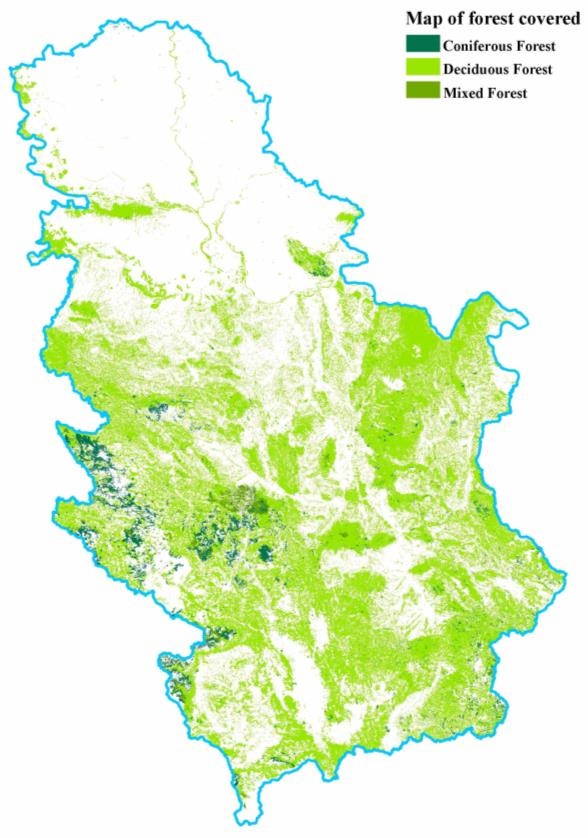
Based on SPOT5 satellite images with resolution of 10 m, epoch 2010/2011, the area under the forest was 31,956 km2, which represents about 36% of the territory of Serbia. The area of deciduous forests was 29,442 km2, the area of coniferous forests is 1,965 km2, and the area of mixed forests was 549 km2. Apart from loess planes, swamps, rites, salt marshes and high-mountain belts above the natural upper forest border, the territory of Serbia belongs to forest biomes. In fact, natural conditions in Serbia are such that primary climatic forest vegetation could cover 85% of its surface. Although there are no written data, it is assumed that in the medieval Serbian state, the forestry was approximate to the potential, between 75 and 80%. Because of this, Stefan Nemanja (1113 – 1199) allowed the inhabitants of Dubrovnik to cut our forests for the needs of shipbuilding without compensation. Forest cutting continued after Nemanja, due to the expansion of pasture areas and the development of mining. Forest cutting continued during the time when the forests were exploited not only for to mining, but also because of the more developed cattle breeding. Therefore, Emperor Dušan (1308-1555) by Article 23 of the Dušan Code of 1349, banned the miners of Sas from indefinitely reducing the forests and settling down on the areas that have been cleared. The ban on unlimited deforestation was later expanded to the nobility, and the inhabitants of the villages Ljubižnja and Skorobijnja in the Prizren region were forbidden to “poorate” the mountain on the property of the Prizren monastery. At the time of the Turkish occupation, from 1718 to 1721, only 50,000-60,000 inhabitants lived in Serbia due to population displacement. Due to depopulation, the forests conquered their old premises and covered over 80% of the territory. However, at the beginning of the 19th century, especially after the First Serbian Uprising, the population began to return. In 1820, 500,000 inhabitants lived in Serbia, and 2,492,882 in 1900, which led to massive deforestation, primarily for the expansion of agricultural land and extensive livestock breeding. For this reason, in 1885, the forests decreased to only 32%. This was not the end of the destruction of forest vegetation, after the Second World War, it covered only 21.4 % of the territory, which is the smallest forest covering surface in the history of these areas. Thanks to the measures of afforestation, melioration, care and protection of forests, as well as migration of the population from mountainous areas, in the second half of the 20th century, the area under forests was somewhat increased, so today the forests cover 30.6% of Serbia. However, Vojvodina, as a typical agrarian area, has remained permanently without forests.
Indicator Name: Trend of Forest area change in Serbia
Institution/Author: Environmental Protection Agency/Slaviša Popović
Use and interpretation:
The indicator monitors the forest surface, according to the classes of deciduous, conifer and mixed forests, compared to the entire surface of the Republic of Serbia.
Key question(s) which indicator helps to answer
The indicator helps to answer the question: What is the trend of changes of forested area in Serbia?
Use of indicator
The indicator shows trend of changes of forested area in the territory of the Republic of Serbia. It is used by forest authorities but also by biologist and ecologists in order to assess percentage of forested area compared to the total area of the Republic of Serbia. Changes in forest area due to afforestation, renewal or deforestation, represent an indicator for sustainable forest management and to monitor the role of forest ecosystems in the global carbon cycle.
Scale of appropriate use
Data gathered based on SPOT5 10-m resolution satellite shots 2010/2011 to calculate the forested surface. Trend of changes of forested area in the territory of the Republic of Serbia according to the data of Corina Land Cover.
Potential for aggregation:
Meaning of upward or downward trends (“good or bad”)
Forested area in the Republic of Serbia is 31,956 km2. It was increased for about 100% in comparison with the year 1953.
Possible reasons for upward or downward trends:
Trend in changes in forest areas, according to the preceding inventories and censuses and according CORINE Land Cover in ha and/or % of the territory or part of the territory.
Implications for biodiversity management of change in the indicator:
The indicator is traditionally described in annual state of the environment reports in Serbia, and it is determined as biodiversity indicator, according to the Rulebook on the National list of environmental protection indicators (Official Gazette of the Republic of Serbia No. 37/2011).
Units in which it is expressed:
Surface in hectares (ha) or percentage of the territory or part of the territory.
Description of source data:
Republic Geodetic Authority, Environmental Protection Agency, Ministry of agriculture-Directorate for forest
Calculation procedure:
Based on SPOT5 10-m resolution satellite shots 2010/2011, the forested surface was determined, in terms of total surface, the surface of deciduous forests, the surface of coniferous forests, and the surface of mixed forests. Total forested surface was 31,956 km2, which makes up around 36% of the territory of the Republic of Serbia.
According to the data of CORINE Land Cover for 2018, the forested area in the Republic of Serbia (without the territory of the AP of Kosovo and Metohija) was 2,380,000 ha, which makes up 30% of the territory. For the period of 1953 – 2012, forested surface increased by over 1,200,000 hectares, which is about 100% increase in comparison to 1953.
Most effective forms of presentation:
(graph types, maps, narratives, etc.-give examples where possible):
The best ways to present this indicator are map and graphs and they provide opportunity to monitor progress regarding this indicator and to record trends observed.
Limits to usefulness and accuracy:
(e.g. slow change in response to pressures, poor quality data, limited scope for updating)
There is a problem related to surface that CORINE cover. The surface is more than 5 ha, which means it is not too much precious for foresters, but it provides cheap, user-friendly and comparable data.
Updating the indicator:
Data are updated annually. Data provided by the Statistical Office of the Republic of Serbia are updated biannually.
Closely related indicators
Type of Forest, Forest species
Additional information and comments
| Hystorical data | Data from the forest related Ministry | Forest inventory | CORINE Land Cover | Ortophoto | |
| 1801 | 3622700 | ||||
| 1820 | 3622700 | ||||
| 1841 | 3187972 | ||||
| 1885 | 1546000 | ||||
| 1905 | 1517000 | ||||
| 1938 | 1442669 | ||||
| 1947 | 1342000 | ||||
| 1953 | 1322000 | ||||
| 1958 | 1876000 | ||||
| 1961 | 1923466 | ||||
| 1979 | 1964239 | ||||
| 1990 | 2249677 | ||||
| 2000 | 2266333 | ||||
| 2006 | 2351000 | ||||
| 2007 | 2252400 | ||||
| 2012 | 2373740 | 2653532 | |||
| 2018 | 2380917 |