Key message: In the period from 2006-2018, in the course of the year, almost all natural and semi-natural habitats have increased
Assessment: Changing the surface and fragmentation of natural and semi-natural habitats, according to the CORINE Land Cover typology, in the area of the Ecological Network of Serbia (without the territory of the Autonomous Province of Kosovo and Metohija) is a very important indicator of pressure on natural habitats, but at the same time of the protection efficiency. Inside the area of the Ecological Network of Serbia (without the territory of the Autonomous Province of Kosovo and Metohija), the surface area of almost all natural and semi-natural habitats has increased, while simultaneously reducing the fragmentation of the same habitats in the period 2006-2018.
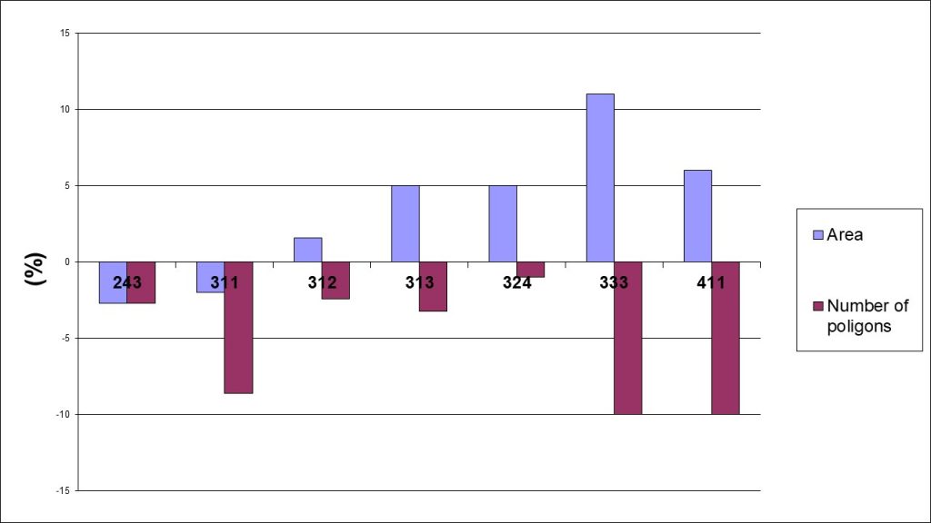
The area of predominantly agricultural land with a significant area under natural vegetation (class 243) decreased by about 2.7%, while the fragmentation decreased by 2.7%. The area of deciduous forests (class 311) was reduced by about 2% with a decrease in fragmentation by 8.6%. The area of coniferous forests (class 312) increased by 1.6% with a decrease in fragmentation by 2.4%. The area of mixed forests (class 313) increased by 5% with a decrease in fragmentation by 3.2%. The surface of the transitional shrub forest vegetation (class 324) increased by 5% with a decrease in fragmentation by 1%. There is no change in the surface of the natural grasslands (class 321) with a decrease in fragmentation by about 4%.
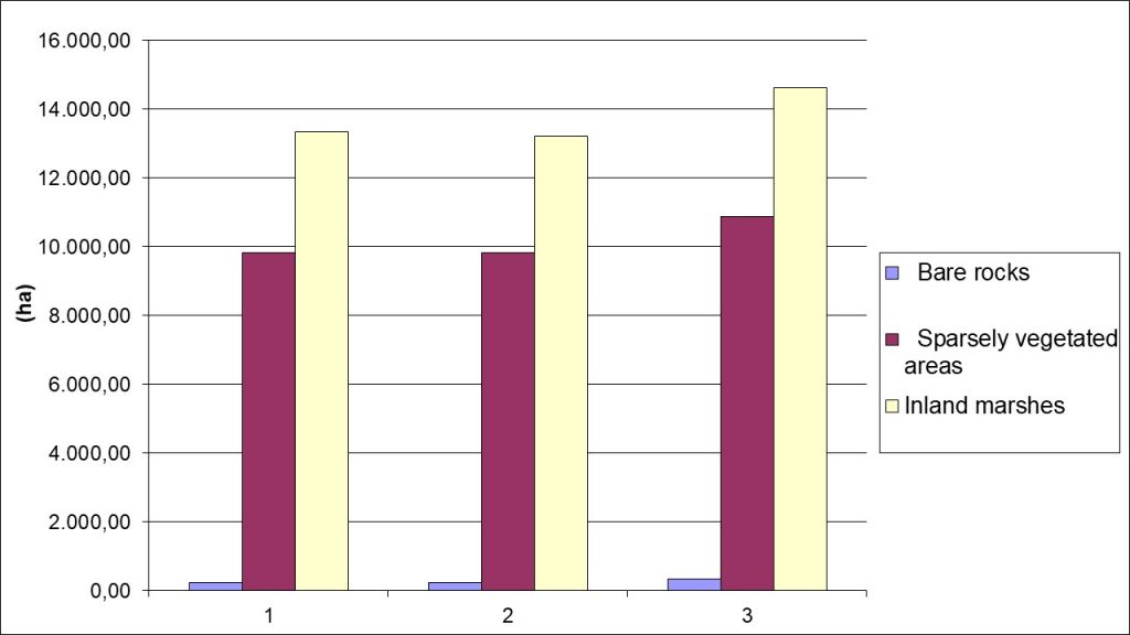
The surface area with scarce vegetation (class 333) increased by 11% with a decrease in fragmentation by 10%. The area of swamp land increased by 6% with a decrease in fragmentation by 11%. It is important to note that the surface of the bare rock (class 332) increased by over 50% with an increase in fragmentation by over 40%.
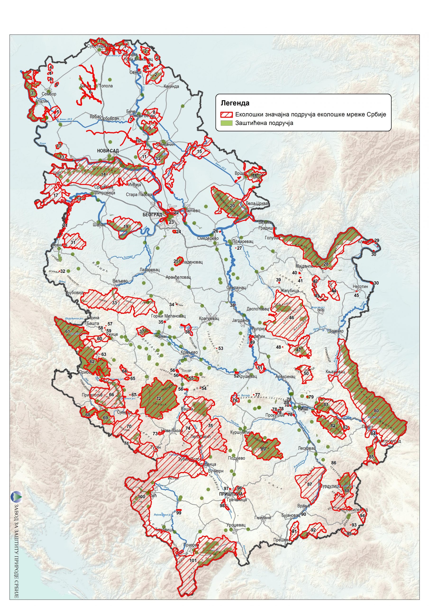
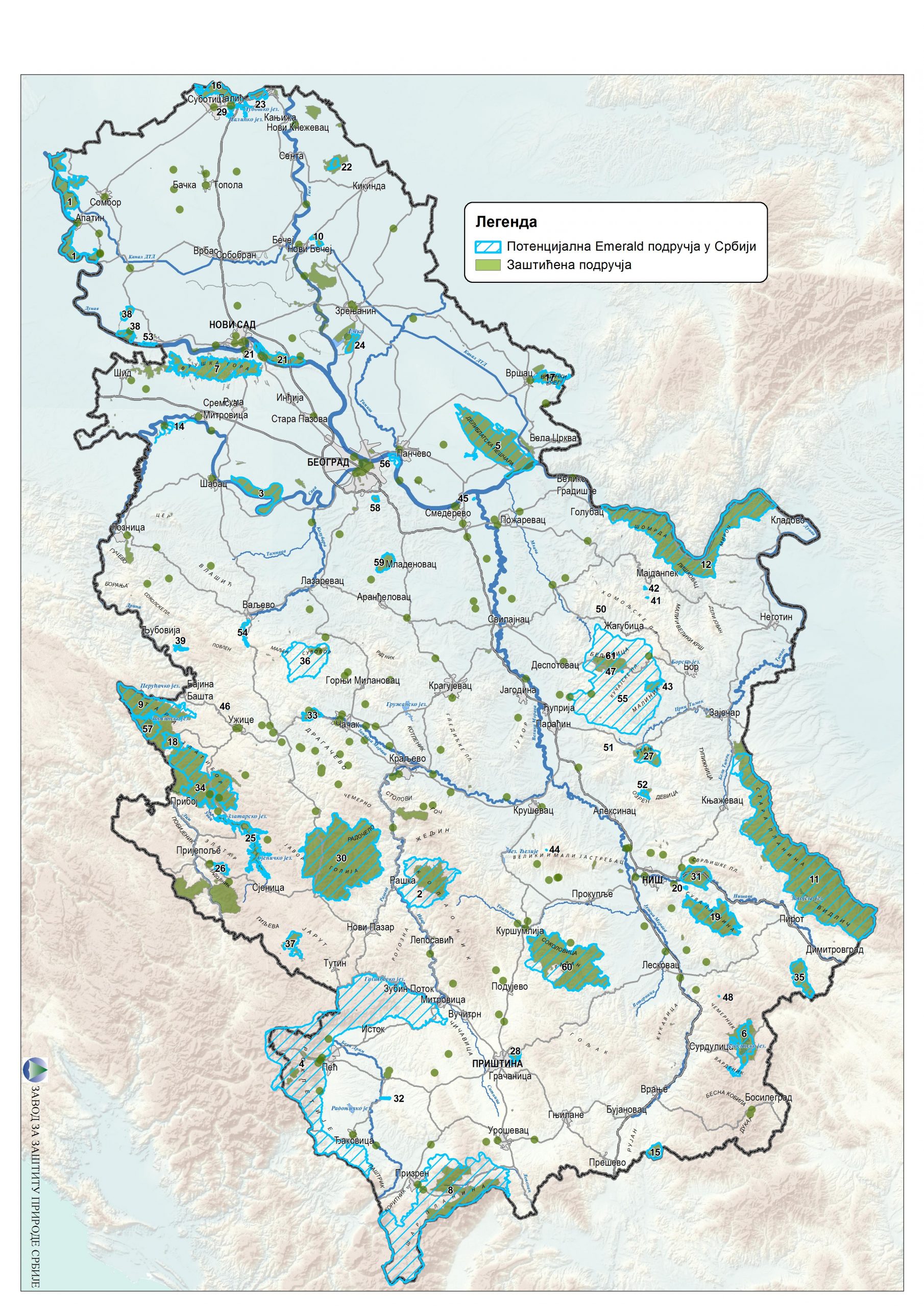
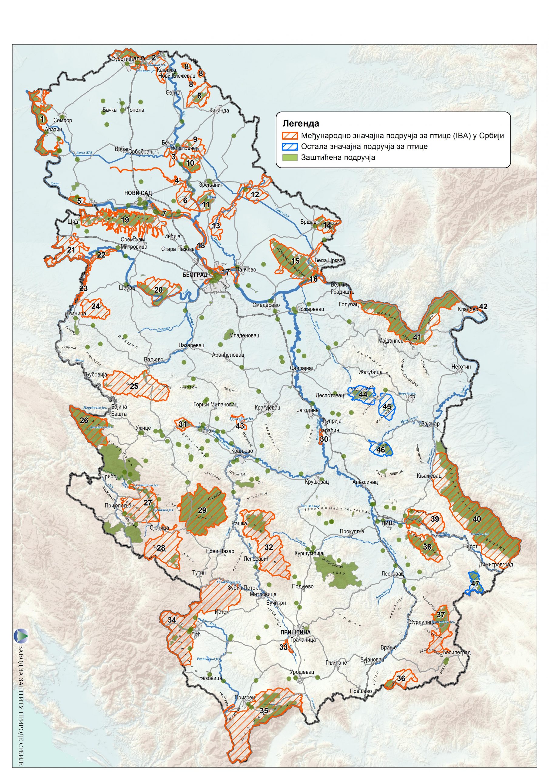
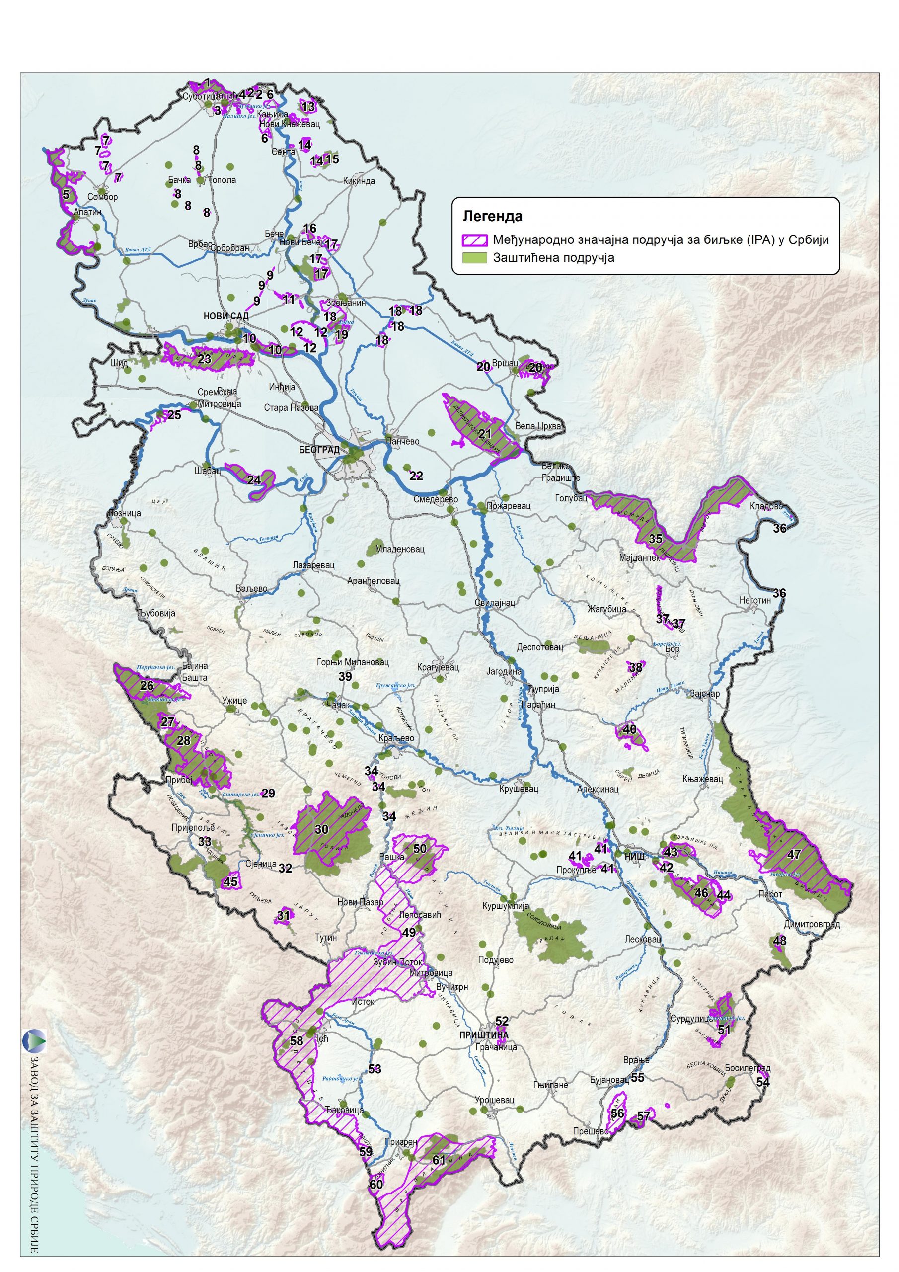
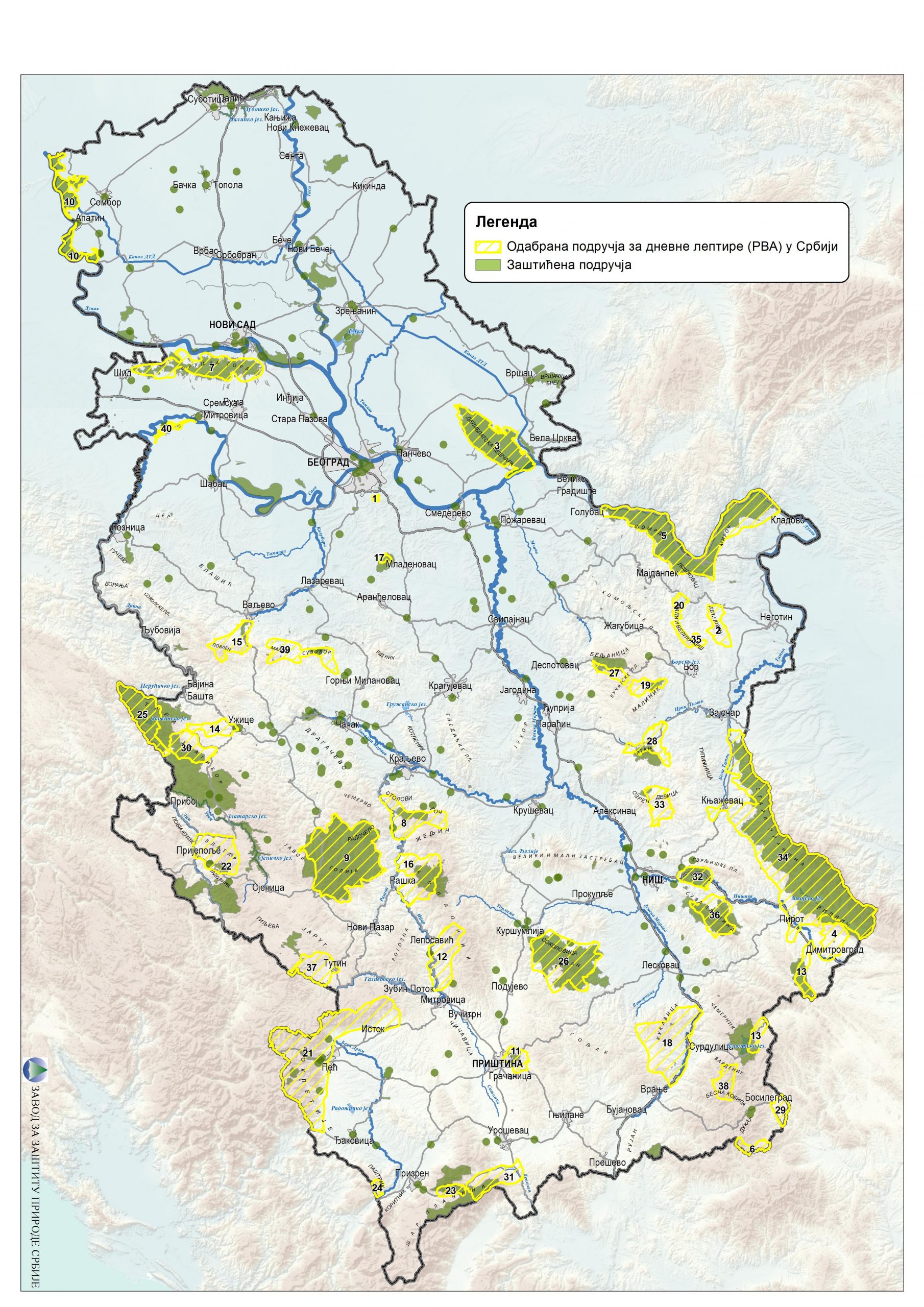
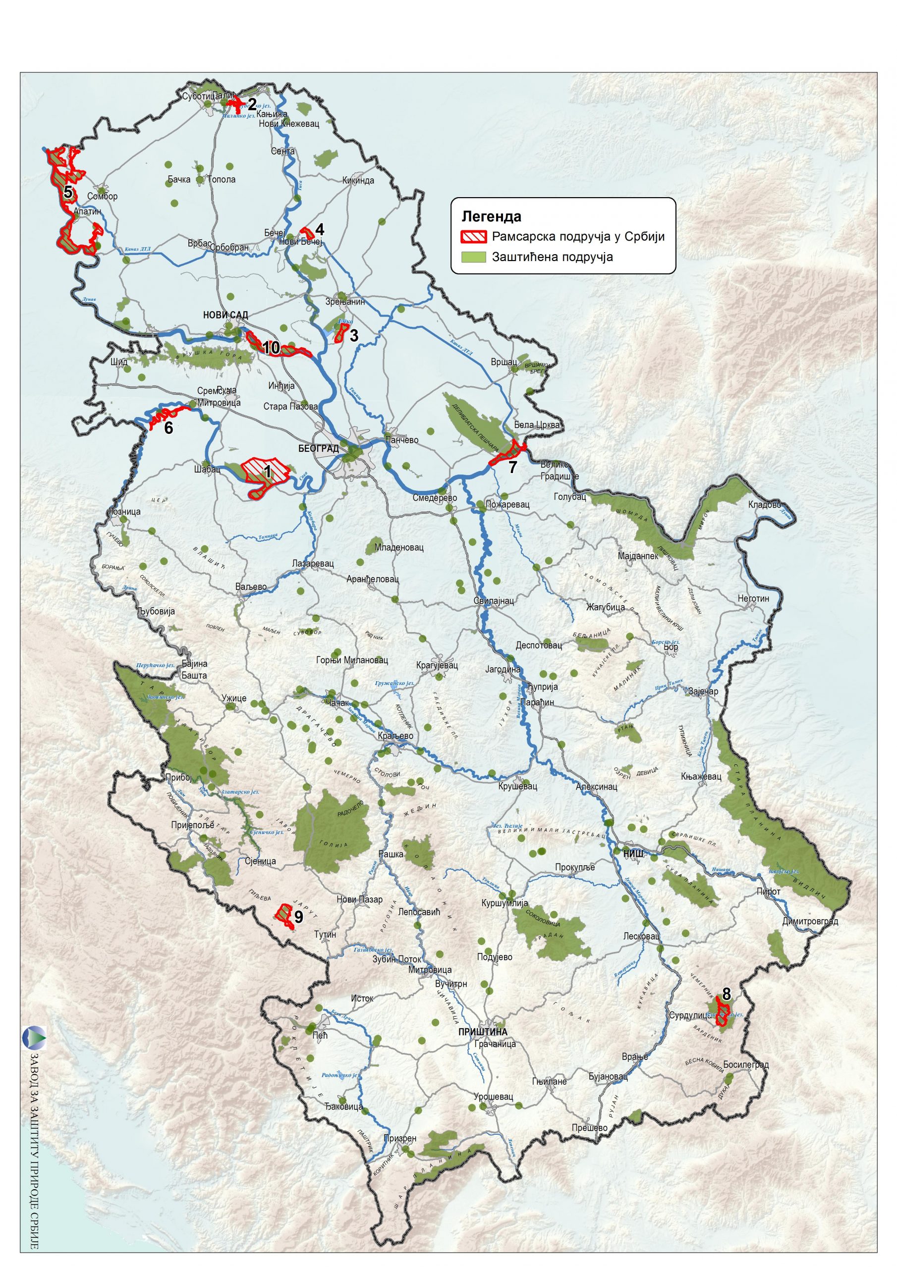
The ecological network of Serbia comprises 101 sites, and it represents an assembly of functionally connected or spatially close ecologically significant areas, which through their biogeographic presence and representativeness significantly contribute to the conservation of biodiversity and sustainable utilisation of resources, including the ecologically significant areas of the EU Natura 2000. Up to now, 61 sites have been nominated for the European Emerald Network. In 2009, 42 Important Bird Areas (IBA) were identified, total coverage of which was 1,259,624 hectares or 14.25% of the territory of the Republic of Serbia. Furthermore, 62 areas of Important Plant Areas (IPA) were defined, and they encompass a surface of 747,300 ha or 8.5% of the territory of the Republic of Serbia. In addition, 40 areas of Prime Butterfly Areas (PBA) were identified. The total surface of all PBA surfaces is 903,643 hectares, which represents 10.2% of the territory of the Republic of Serbia. Ten Ramsar sites cover total area 61,522 ha or 0.7% of territory.
Project Important Plant Areas in Europe – IPA in Europe, coordinated by Plant-life International, is an initiative to point out the habitats that are most important for the preservation of the wild flora of Europe. So far, 399 IPA areas have been identified in the EU countries that have been included in the Natura 2000 network. In the countries that are not yet members of the EU, an additional 510 IPA areas are identified for the conservation of plant species and their natural habitats. In 2005, 59 habitats of international significance were proclaimed protected for the preservation of floral diversity in Serbia. These habitats comprise 8.5% of the territory of Serbia.
Project Important Bird Areas (IBA), managed by Bird Life International, is one of the key projects for the conservation of bird fauna and their habitats. In more than 200 countries around the world, over 10,000 IBA areas have been identified, of which about 4,000 are located in Europe. In 1989, 16 areas were identified in Serbia, 35 in 1997, and in 2009 the number of IBA areas increased to 42. The collection area of these internationally significant areas for birds in our country is 1,259,624 ha, of which 43.7% are located in protected areas.
The project Prime Butterfly Areas in Serbia (PBA) was implemented in 2003 under the auspices of the Butterfly Conservation Europe organisation from the Netherlands. The purpose of the project was to identify and protect habitats important for the preservation of butterfly fauna. In accordance with this project, 40 significant areas have been identified in Serbia for the 38 most important types of butterflies out of 193 types of butterflies we have in our country. The sum of the area important for the survival of the most important types of butterflies amounts to 10.22% of the territory of Serbia.
In the European Union accession process, Serbia has identified areas that should make a part of the Emerald Network, important for preserving biodiversity. The Emerald Network also represents a European ecological network for the conservation of wild flora and fauna and natural habitats in those non-EU countries. The Emerald Network was created in 1998 by the Council of Europe in support of the Berne Convention and preparations for the implementation of the Habitats Directive. This network consists of Areas of Special Conservation Interest (ASCI), that is, habitats of particular national and international significance from the aspect of conservation of biological diversity in the territory of all signatories to the Berne Convention. The project of establishing the Emerald network in Serbia was implemented in 2005 and 2006. In the process of identification of the Emerald area, 61 areas were processed, especially important for the protection and conservation of wild plant and animal species and their habitats. The total surface of these areas is 1,019,700 ha, which makes up about 11.5% of the territory of Serbia. Of the above number of potential Emerald areas, 51 already have the status of protected areas in accordance with national legislation, one area has the status of the Biosphere Reservation, 10 areas are declared Ramsar sites, 36 areas of international importance for plants (IPA), 34 areas of international importance for birds (IBA), 28 areas are selected areas for butterflies (PBA).
In addition to the ecological networks Natura 2000 and Emerald, a Pan-European ecological network is being developed in the area of Europe, defined as an action topic of the Pan-European Biological and Landscape Diversity Strategy (PEBLDS) adopted at the Ministerial Conference in Kiev in 1995. The Pan-European Ecological Network (PEEN) should cover protected areas of national importance, the Natura 2000 and Emerald Ecological Networks, Ramsar sites, internationally significant plant areas (IPAs), internationally significant areas for birds (IBA), selected areas for butterflies (PBA), habitats of rare and endangered species of national and international significance, natural or semi-natural habitats within artificial ecosystems of primarily large agricultural areas. Based on the Convention on the Protection of Wetlands and Their Biodiversity (Convention on Wetlands, Ramsar, 1971), ten protected areas of Serbia have been given the status of internationally significant Ramsar sites. These are: Obedska bara, Carska bara, Ludaško jezero, Slano kopovo, Labudovo okno (part of the special nature reserve of the Deliblatska peščara), Gornje Podunavlje, Zasavica, Vlasina, Koviljsko-petrovaradinski rit and Karajukića bunari on Peštersko polje. The total surface of these areas is 55,630 ha.

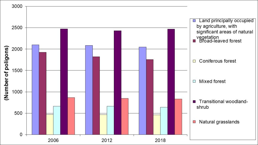

Indicator Name: CORINE Land Cover habitat changes inside Ecological network in Serbia
Institution/Author: Environmental Protection Agency/Slaviša Popović, Nemanja Jevtić
Use and interpretation:
Serbian Environmental Protection Agency in its Annual Reports on Biodiversity Indicators; Reports to the international conventions; Institute for Nature Protection of the Republic of Serbia, Institute for Nature Protection of the Vojvodina Province and managers of the protected areas .
Ecological Network of Serbia comprises 101 ecologically important areas and consists EMERALD areas (61), Ramsar areas, Important plant areas (61 IPA), Important bird areas (42 IBA) and Prime butterfly areas (40 PBA). The total area covered by Ecological network is 1,019,269 hectares, which represents 11.54% of the territory of the Republic of Serbia. Regulation on the ecological network (Official Gazette no. 102/2010) defines criteria of ecological network functioning.
Key question(s) which indicator helps to answer
The indicator helps to answer two questions: What are the habitats of interest for the protection? and: What are the species that should be protected?
Use of indicator
For measuring progress in line with biodiversity protection issues, in terms of future Natura 2000 system and according to national criteria and objectives.
Scale of appropriate use
Indicator represents surface and percentage of the territory under protection as Ecological network, compared to total surface of the Republic of Serbia. The indicator is compatible with indicators of the same scale, such as protected areas biodiversity indicator.
Potential for aggregation:
Meaning of upward or downward trends (“good or bad”)
The Ecological network was established in 2011 and there were no changes in number and structure of the area of interest for the protection.
Possible reasons for upward or downward trends:
Inside the area of the Ecological Network of Serbia (without the territory of the Autonomous Province of Kosovo and Metohija), the surface area of almost all natural and semi-natural habitats has increased, while simultaneously reducing the fragmentation of the same habitats in the period 2006-2018.
The area of predominantly agricultural land with a significant area under natural vegetation (class 243) decreased by about 2.7 %, while the fragmentation decreased by 2.7 %. The area of deciduous forests (class 311) was reduced by about 2% with a decrease in fragmentation by 8.6 %. The area of coniferous forests (class 312) increased by 1.6 % with a decrease in fragmentation by 2.4 %. The area of mixed forests (class 313) increased by 5 % with a decrease in fragmentation by 3.2 %. The surface of the transitional shrub forest vegetation (class 324) increased by 5 % with a decrease in fragmentation by 1 %. There is no change in the surface of the natural grasslands (class 321) with a decrease in fragmentation by about 4 %.
The surface area with diluted vegetation (class 333) increased by 11 % with a decrease in fragmentation by 10 %. The area of swamp land increased by 6 % with a decrease in fragmentation by 11 %. It is important to note that the surface of the bare rock (class 332) increased by over 50 % with an increase in fragmentation by over 40.
Implications for biodiversity management of change in the indicator:
This indicator is important to monitor the state of habitats and species of interest for the protection, and revision can be launched according to the Regulation on the ecological network (Official Gazette no. 102/2010).
Units in which it is expressed:
The units are hectares (ha) and percentages of the total area (%), and they are used to express the indicator.
Description of source data:
Institute for nature protection of the Republic of Serbia
Institute for the nature protection of the Vojvodina Provence
Calculation procedure:
The indicator is calculated by analysing the number and size of the areas under the Ecological network, from GIS data base.
Most effective forms of presentation:
(graph types, maps, narratives, etc.-give examples where possible):
The best ways to present this indicator are tables and map.
Limits to usefulness and accuracy:
It is necessary to establish not only polygons under the Ecological network, but also corridors. Update of the Regulation on Ecological Network is necessary.
(e.g. slow change in response to pressures, poor quality data, limited scope for updating)
Updating the indicator:
There is no regular update, instead some new area important for the protection is designated.
Closely related indicators
Protected areas
Additional information and comments
Table 1: CORINE Land Cover habitat changes inside Ecological network in Serbia (ha)
| 2006 | 2012 | 2018 | ||
| 243 | Land principally occupied by agriculture, with significant areas of natural vegetation | 138.168,00 | 138.234,00 | 134.427,00 |
| 311 | Broad-leaved forest | 612.132,00 | 611.096,00 | 605.678,00 |
| 312 | Coniferous forest | 55.234,70 | 54.982,80 | 56.121,10 |
| 313 | Mixed forest | 72.625,50 | 72.752,80 | 76.343,50 |
| 324 | Transitional woodland-shrub | 214.385,00 | 215.907,00 | 225.402,00 |
| 321 | Natural grasslands | 121.490,00 | 121.205,00 | 121.451,00 |
| 331 | Beaches, dunes, sands | 234,80 | 205,12 | 144,08 |
| 332 | Bare rocks | 227,27 | 227,28 | 342,23 |
| 333 | Sparsely vegetated areas | 9.837,26 | 9.820,76 | 10.882,20 |
| 411 | Inland marshes | 13.346,40 | 13.207,60 | 14.622,90 |
| 511 | Water courses | 28.318,20 | 28.463,70 | 29.129,70 |
| 512 | Water bodies | 15.784,20 | 15.625,50 | 16.788,50 |
Table 2: CORINE Land Cover habitat changes inside Ecological network in Serbia (Number of poligons)
| 2006 | 2012 | 2018 | ||
| 243 | Land principally occupied by agriculture, with significant areas of natural vegetation | 2102 | 2084 | 2046 |
| 311 | Broad-leaved forest | 1924 | 1820 | 1758 |
| 312 | Coniferous forest | 471 | 468 | 460 |
| 313 | Mixed forest | 662 | 665 | 641 |
| 324 | Transitional woodland-shrub | 2471 | 2430 | 2467 |
| 321 | Natural grasslands | 868 | 847 | 835 |
| 331 | Beaches, dunes, sands | 7 | 6 | 5 |
| 332 | Bare rocks | 5 | 5 | 7 |
| 333 | Sparsely vegetated areas | 136 | 136 | 122 |
| 411 | Inland marshes | 205 | 205 | 183 |
| 511 | Water courses | 130 | 119 | 98 |
| 512 | Water bodies | 109 | 109 | 108 |
