Key message: Decrease in the average species number found for community Nardetum strictae is related to the abandonment of this formerly grazed pasture. Observed decrease of species found for the hilly community Agrostietum capillaris might be related to an influence of abandonment and occurrence of weeds and trees or shrubs.
Assessment: Stara Planina Mt. is a wide mountain range in eastern Serbia and owing to the unique natural values, the Government of the Republic of Serbia issued the Decree on Protection of the Nature Park „Stara Planina“ („Official Gazette of the Republic of Serbia“, No. 19/97) in 1997, by which the Stara Planina Mt., as a natural asset of outstanding importance, was put under protection within the 1st protection category. So far, 89 different habitat types were recorded on this mountain, along with the habitat diversity, the Stara Planina Mt. represents one of the floristically most diverse parts of Serbia and the entire Balkan Peninsula. The overall richness and diversity of species, as well as the presence of numerous endemic and relic forms, point to a specific genesis that influenced the exceptional diversity of this mountain.
Apart from different types of forests (e.g. oak, beech, conifer forest, etc.) there is variety of grasslands in range of very wet communities (e.g. Calthion types) towards very dry alpine grasslands (e.g. Poetum violaceae).
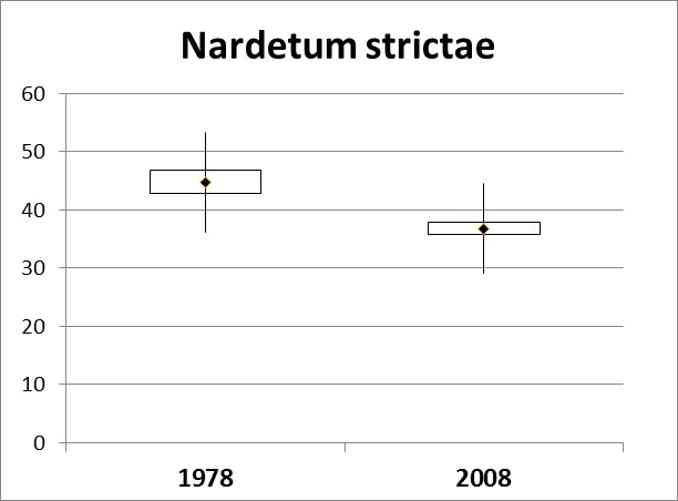
Grasslands of Nardetum strictae sensu lato are the most spread in the mountain zone, occurring in the zone of spruce and subalpine shrub vegetation, usually on steep slopes, between 1.400-2.000 altitude. The mountain grassland community Nardetum strictae is developed mostly on silicate soils. In the community recorded on NP Stara planina, the following species dominate: Nardus stricta, Agrostis capillaris, Poa violacea and Polygonum bistorta. In 1978 the average number of species was 44.81 in community recorded on several mountain sites in NP Stara planina, while on the same sites, after thirty years the number of species decreased at 36.83. Decrease in the average species number found for community Nardetum strictae is related to the abandonment of this formerly grazed pasture. The change in floristic composition of grasslands based upon the Sørensen community index, was 61.54%, which is highly important sign of significant community change and should be used as valuable indicator.
Graph. 1. Change of mountain grassland community Nardetum strictae

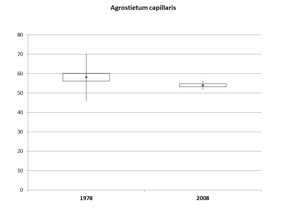
The hilly grassland community Agrostietum capillaris develops on calcareous or silicate soils in altitude range of 500-1000m. The following grass species are the most abundant in ass. Agrostietum vulgaris: Festuca valesiaca, Agrostis capillaris, Danthonia alpina, and Koeleria pyramidata. In 1978 , the average species number per plot was 58.22 , and upon our research 54.01. Releves were studied three times a year at the same location and in the same vegetation period. Observed decrease of species found for the hilly community Agrostietum capillaris might be related to an influence of abandonment and occurrence of weeds and trees or shrubs, such as Rosa canina, Clematis vitalba, Crataegus monogyna, Corylus avellana, Malus sylvestris, Cornus sanguineus and Ononis spinosa which affected appearance and abundance of some typical grassland plants, such as some legumes (Trifolium campestre and T. montanum), which were not recorded, in addition to some of previously recorded species like Anthoxanthum odoratum. The change in floristic composition of grasslands based upon the Sørensen community index, were 69,88%.
Graph. 2. Change of mountain grassland community Agrostietum capillaris

Indicator Name: Changes of floristically composition of hilly grassland community Agrostietum capillaris on Nature Park Stara Mt.
Institution/Author: University of Belgrade, Faculty of Agriculture, Department of Agrobotany/prof. dr Zora Dajić Stevanović
Use and interpretation:
Significant decrease of species found for the hilly community Agrostietum capillaris related to an influence of abandonment and lack of management.
The indicator is obtained by mapping grassland vegetation with great biological diversity by using:
– Data on the distribution of grassland vegetation;
The indicator is presented as a graphic, as % of floristically change of grassland community
Stara Planina Mt. is a wide mountain range in eastern Serbia and because of the unique natural values, the region was proclaimed into the protected area upon Decree on Protection of the Nature Park “Stara Planina” (Official Gazette of the Republic of Serbia No. 19/97) in 1997, by which the Stara Planina Mt., as a natural asset of outstanding importance, was put under protection within the 1st protection category. So far, 89 different habitat types were recorded on this mountain, along with the habitat diversity, the Stara Planina Mt. represents one of the floristically most diverse parts of Serbia and the entire Balkan Peninsula. The overall richness and diversity of species, as well as the presence of numerous endemic and relic forms, point to a specific genesis that influenced the exceptional diversity of this mountain.
Meadows and pastures of Agrostietum capillaris have wide distribution in Serbia, mainly in hilly and mountain region. There are estimations that near 30% of the total semi-natural grassland area is occupied by Agrostietum type, accounting for about 200.000 ha (Statistical Gazette of R. of Serbia, 2015).
The hilly grassland community Agrostietum capillaris develops on calcareous or silicate soils in altitude range of 500-1000m. The following grass species are the most abundant in ass. Agrostietum vulgaris: Festuca valesiaca, Agrostis capillaris, Danthonia alpina, and Koeleria pyramidata.
Thanks to the records obtained in 1978 (Mišić et al., 1978) at the same studied site (Ponor GPS: 43,25821 and 22,7548) it was possible to monitor the biodiversity changes of this semi-natural community. In 1978 , the average species number per plot was 58.22 , and upon our research 54.01 (Dajić Stevanović et al., 2008) (Table 1). Releves were studied three times a year at the same location and in the same vegetation period.
Observed decrease of species found for the hilly community Agrostietum capillaris might be related to an influence of abandonment and occurrence of weeds and trees or shrubs, such as Rosa canina, Clematis vitalba, Crataegus monogyna, Corylus avellana, Malus sylvestris, Cornus sanguineus and Ononis spinosa which affected appearance and abundance of some typical grassland plants, such as some legumes (Trifolium campestre and T. montanum), which were not recorded, in addition to some of previously recorded species like Anthoxanthum odoratum.
The change in floristic composition of grasslands based upon the Sørensen community index, were 69,88%.
The indicator shows highly valuable in terms of biodiversity in relative to the total agricultural area.
The indicator is obtained by using:
– Application of Braun-Blanquet methodology for phytosociological recording performed at the same geographic position
The indicator is presented as % of decrease in species number in the studied grassland community.
Mišić, V., Jovanović-Dunjić, R., Popović, M., Borisavljević, L., Antić, M., Dinić, A. & Blaženčić, Ž. (1978). Plant communities and habitats of the Mt. Stara Planina, SANU, Belgrade (in Serbian).
Dajić Stevanović, Z., Peeters, A., Vrbničanin, S., Šoštarić, I., & Aćić, S. (2008). Long term grassland vegetation changes: case study Nature Park Stara Planina (Serbia). Community Ecology 9(Supplement 1), 23-31.
Potential for aggregation:
Bad trends- Changes in grassland flora and vegetation in the south-east region of Serbia – Nature park Mt. Stara Planina
Decrease of species number found for the hilly community Agrostietum capillaris might be related to an influence of lack in traditional management, primarily grazing (Table 2).
Possible reasons for upward or downward trends:
Downward trends are caused by inadequate management and grasslands abandonment
Implications for biodiversity management of changes in the indicator:
Inadequate management and lack of traditional agricultural practices significantly change the typical floristic composition of grassland vegetation enabling spreading of undesirable, weed or woody species causing decrease in presence and abundance of some typical grassland species.
Units in which it is expressed:
% of change in species number
Description of source data:
Source data is stored in Grassland Vegetation of Serbia Database. The vegetation database are registered in GIVD, GIVD No. EU-RS-002, (www.givd.info), EVA (euroveg.org/eva-database) and sPlot (GrassPlot, GIVD ID EU-00-003). Deputy custodian of database is prof. Dr Zora Dajić Stevanović.
AĆIĆ, S., PETROVIĆ, M., DAJIĆ STEVANOVIĆ, Z. & ŠILC, U. (2012): Vegetation Database Grassland Vegetation of Serbia. – Biodivers. Ecol. 4: 418–418.
Calculation procedure:
Selection of grassland communities and standard phytocoenological method of Braun Blanquet (1964) for vegetation investigation. The total species number was counted in each relevé of formerly and at present studied communities. Means for each studied community were compared by unpaired Student’s t-test and homogeneity of variance(F-test) where “community” was treated as categorical variable using STATISTICA 6.0. Sørensen coefficient of community similarity (CC), (Magurran 1988) was used to calculate a long-term change of floristic structure within a community.
Most effective forms of presentation:
(graph types, maps, narratives, etc.-give examples where possible): narrative
Table 1. Average species number of grassland community Agrostietum capillaris
Community | Past | Present | p-level |
Agrostietum capillaris | 58.22±11.96 | 54.01±2.21 | ** |
Table 2. Impact on biodiversity because of changes of grassland communities
Area | Main changes | Negative impact on biodiversity |
Hilly and mountain areas | Inadequate use Insufficient grazing Abandonment ↓ Disappearing of grassland ecosystems | Succession Grasslands → shrub vegetation → Forest Degradation Missing plant species Spread of undesirable species: woody, shrub and herbaceous species ↓ Disappearance of plant species and ecosystem diversity (disappearing of grassland community) |
Limits to usefulness and accuracy:
Low accessibility to studied sites, undeveloped methodology, lack in financial support for such analyses
Updating the indicator:
It could be recommended the period of 5 years for regular monitoring
Closely related indicators:
Protected areas, protected species, protected habitats
Additional information and comments
Serbia