Institution/Author: University Singidunum/ dr Lidija Amidžić
The problem of preserving biodiversity in the Stara Planina Nature Park is a small share of the area under the 1st degree of protection regime (3.65 %) and the fragmentation of habitats in the 2nd and 3rd degree of protection regime.
Based on the Spatial Plan of the Nature Park and the tourist region of Stara Planina (Official Gazette of the Republic of Serbia No. 115/08), in high mountainous area of the Nature Park Stara Planina has been allocated 6 sectors of the Alpine ski trials as follows:
- the sector “Golema Reka” in the territory of the municipality of Knjaževac with a capacity of 9 500 to 15 700 skiers, with 10 main lifts and 30 to 63 km of alpine ski trails;
- the “Topli Do” sector in the territory of the Municipality of Pirot (Basin of the Toplodolska River), with a capacity of 8 000 to 13 400 simultaneous skiers, with nine main lifts and 25 to 54 km of alpine ski trails;
- the “Mramor / Gostuša” sector in the territory of the municipality of Pirot (basins of Toplodolska and Gostuška rivers) with a capacity of 4 800 to 8 000 skiers, with six main lifts and 19 to 32 km of alpine ski trails;
- the sector “Dojkinci / Kopren” in the territory of the Municipality of Pirot (the basins of the Dojkina and Jelovica rivers) with a capacity of 5 900 to 9 800 skiers, with seven main lifts and 20 to 39 km of alpine ski trails;
- the sector “Jelovica / Rosomač” on the territory of the municipality of Pirot (basins of Jelovica and Rosomačka rivers) capacity of. 7 000 to 11 600 simultaneous skiers, with 10 main lifts and 21 to 46 km of alpine ski trails;
- the sector “Senokos / Srebrna glava ” in the territory of Dimitrovgrad Municipality (the river basin of the Kamenica River) with a capacity of 6 000 to 10 000 simultaneous skiers, with seven main lifts and 28 to 40 km of alpine ski trails.
In accordance with the strategic objectives defined in the said Regional Plan, the Nature Park “Stara Planina” will enable the presence of 41 200 to 68 500 simultaneous skiers to use the capacity of 49 lifts and 143 to 274 km of ski trails in the protection regime II and III degrees which is an example of extreme fragmentation degradation and destruction of sensitive natural ecosystems in the protected area.
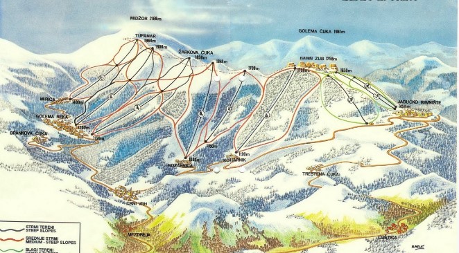
Table 1: Length and surface of ski trails
| Minimum length of ski trails (km) | Minimum area under ski trails (ha) | |||||
| Protection regime | II degree | III degree | in total | II degree | III degree | in total |
| Sector | ||||||
| Golema Reka | 19 | 11 | 30 | 95 | 55 | 150 |
| Topli Do | 9 | 16 | 25 | 45 | 80 | 125 |
| Mramor / Gostuša | 4 | 15 | 19 | 20 | 75 | 95 |
| Dojkinci / Kopren | 5 | 15 | 20 | 25 | 75 | 100 |
| Jelovica / Rosomač | 14 | 7 | 21 | 70 | 35 | 105 |
| Senokos / Srebrna glava | 19 | 9 | 28 | 95 | 45 | 140 |
| Vidlič | 0.85 | 10,8 | 11,7 | 4,3 | 54 | 75 |
| In total | 70.85 | 83.8 | 154.65 | 354.25 | 419 | 773.25 |
Table 2: Surface structure according to protection regimes
| Nature Park “Stara planina” | ||
| Surface structure according to Protection regimes | km² | % |
| Protection regime 1st degree | 41.60 | 3.65 % |
| Protection regime 2nd degree | 196.79 | 17,21 |
| Protection regime 3rd degree | 904.93 | 79.15 |
| Total surface | 1143.32 | 100% |